Well here’s a question for the ages.
Say you are trapped on the trails and all you have is a CW Morse radio to relay your coordinates to rescuers. Say you have limited battery capacity and need to ensure the message gets through on the first try. Say you know your coordinates to within several meters.
The question becomes…
What geographic format is the fastest to transmit?
Let’s assume for the moment everything is WGS84 datum and forget about NAD27 for this exercise. Two contender formats for expressing Latitude and Longitude come to mind: Good old degrees and the relative newcomer Maidenhead Locator System.
Degrees, Deg. Minutes, Deg. Min. Seconds
Everyone is familiar with degrees formatting right? Google it for more information. The funny thing about using degrees latitude and longitude are the various ways folks represent the same data. Some use only degrees as a floating point number. Others use degrees and minutes where the minutes is a floating point number. Perhaps the most poetic format is degrees, minutes and seconds. Let’s examine the format, but first…
It’s time to pick a point on Earth to serve as our example. It should be on a hiking trail where you might find refuge from sudden poor weather conditions. Hmmmm… ah I know. Let’s pick the old site of Beacon 32 on the Washington, D.C. to Cincinnati Airway. This site still has the generator shed to serve as emergency shelter for hikers. It is near the Tuscarora trail system. This will be a perfect example. Let’s look at the various traditional ways to express this spot on Earth…
- In Degrees (D)…
- 38.97840 -078.63162
- In Degrees and Minutes (DM)…
- 38 58.704N 078 37.897W
- In Degrees, Minutes and Seconds (DMS)…
- 38 58 42.25N 078 37 53.82W
Note the Degrees format most often uses positive (+ or nothing) and negative (-) signs to express +/- 90 degrees Latitude and +/- 180 Degrees Longitude. The other two formats most often say North or South for latitude (rather than + or -) and East or West Longitude (rather than + or -). The use of NS-EW vs. + and – result in almost the same number of characters. Also note the assumption Latitude is first. I’m pretty sure I have always seen it this way.
The plus is East and minus is West approach is a 128 year old convention…
In 1884, the International Meridian Conference, meeting in Washington, agreed to adopt the “meridian passing through the center of the transit instrument at the Observatory of Greenwich as the initial meridian for longitude,” resolving that “from this meridian longitude shall be counted in two directions up to 180 degrees, east longitude being plus and west longitude minus” [1]
…however hams have ensured confusion ever since the creation of the country files which swapped the convention [2] – This embarrassing mistake propagates to several logging programs and doesn’t help our image. The use of NS or EW reduces ambiguity. ADIF, for example, uses the NS EW approach. [3]
Maidenhead Locator System
The Maidenhead Locator System [4], often known simply as Grid Squares, removes this ambiguity by defining precisely ever increasing two character pairs where the first character always defines Longitude and the second defines Latitude. Each new pair increases the resolution. This system was developed with hams in mind and is meant to express location, to a certain precision, in a very short string of characters. Most hams use four or six digits. For the Airway Beacon location this results in…
- FM08
- FM08qx
However, the best the above can do is specify a box about 30,000 by 15,000 feet. Hardly effective at helping rescuers find you in your Airway Beacon generator shack.
The good news is Maidenhead can continue the letter and number pairs until we get the resolution we want. To get to within ten feet or so we have…
- FM08qx44et95
The potential problem with the above is the fifth and six pair are not formally defined.
Comparison of the Formats
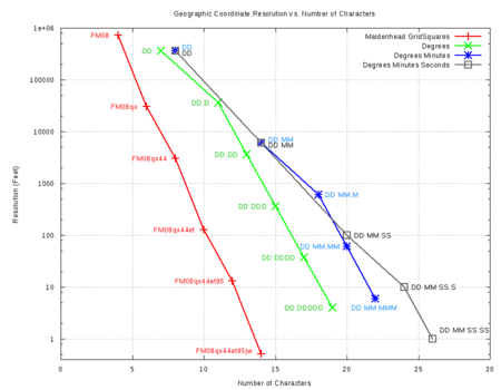
The character count in the Maidenhead Locator System is remarkably thrifty. Let’s compare the three traditional formats with Maidenhead on character count remembering the D, DM and DMS labels represent the format for a string containing both latitude AND longitude…
To add interest to the graph, each geographic location format is shown in ever increasing character count to reveal the trends towards finer resolution. My goal was to continue until the resolution is about 10 feet or so. The y-axis is logarithmic base 10. If you look close, you can see the slopes vary a bit. This correlates with the radix of the additional character(s). For numbers this is obviously base 10. The first two letters of Maidenhead (not shown) are base 18 while subsequent letters are base 24; The slopes of the Maidenhead format swaps back and forth between radix 10 and 24. The two character jump from Degrees to Minutes is base 60, but with two characters; The same goes for Minutes to Seconds. The straight Degrees format is radix ten for every new character.
Transmit Time
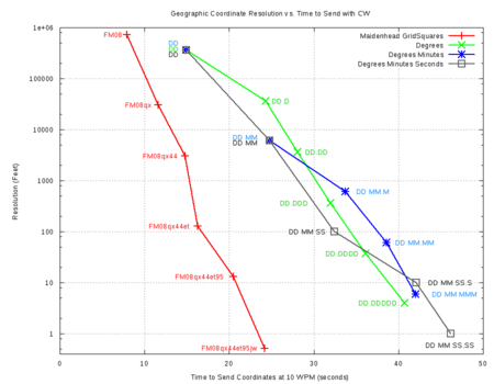
It’s quite clear Maidenhead Locator System does a good job conveying information in the fewest characters thanks to the use of radix 18 and 24 letter codes. A simple count of characters should be proportional to the time to send if using something like RTTY or Packet. The time to send Morse Code, however, varies quite a bit among the characters; You need only compare the single dit of the letter ‘e’ to the five dashes of the number ‘0’ or any of codes for punctuation marks to understand why. What will this mean for send times of the D, DM, DMS and Maidenhead systems? I measured the time to send the various formats using a Morse Trainer software set to 10 WPM and a stop watch. Let’s look at this graph…
All the traditional D, DM and DMS formats use numbers and special characters. These are the longest characters in Morse Code. Longer send times result. Maidenhead mixes letters and numbers about even. Since letters, on average, are shorter than numbers and punctuation, the Maidenhead system benefits with much shorter send times.
Conclusion
The Maidenhead Locator System wins big on sending time, but will anyone know how to interpret your position information? Would you know how to create the 4th, 5th and 6th pairs from your GPS? I can’t really answer that here, but now, at least, you have a little more information.
73
John, kx4o
References
- Snyder, John P. (1987). Map Projections: A Working Manual. (p 9). Washington, D. C., U.S. Department of the Interior, U.S. Geological Survey
- Reisert, James J. (2012). Amateur Radio Country Files.
- The Independent ADIF Site (2012). ADIF 3.
- Wikipedia (2012). Maidenhead Locator System.


